Showing posts with label Weather. Show all posts

Sunday, 2 March 2014

Radio and Weather Statistics for February 2014

February 2014 has continued wet with many floods across the country.

My radio and weather statistics for January are as follows:

Radio Operation

Total number of contacts: 34

Modes

JT65:  34

A poor month again for radio operation, not much time to get on.

Weather

Total rainfall for the month: 132mm

Average temperature: 6.6 degrees centigrade

Maximum temperature of 12.9 on the 24th February at 14.34
Minimum temperature of 1.7 on the 28th February at 00:57


The weather during the month has again been very wet and windy with a succession of low pressure areas running from the Atlantic across the country. As can be seen from the minimum temperature being above freezing point it has also been a mild month.

Tuesday, 18 February 2014

A Cloud Free Day - Satellite Picture of Flooding

Sunday was a rare day of sunshine and clear blue skies. The weather satellite pictures received via EUMETCast showed the UK in a rare state of being almost cloud free.

The following picture shows the UK from a Metop AVHRR pass.


© EUMETSAT (2014)

It is not really clear from the above picture, but when viewed on a large screen, flooding along the River Thames and the Somerset Levels stands out very well.

I took the following detail from the above picture. This shows the Somerset Levels area with the extensive flooding clearly visible. It will be interesting to compare this with a picture later in the year when hopefully the area has dried out.

© EUMETSAT (2014)
 
After the storm overnight Friday into Saturday, the weather has improved, although still some rain, not as heavy as previous weeks.
 

Friday, 14 February 2014

A Conveyor of Low Pressure Areas

So far this year, we have seen a succession of low pressure areas come across the Atlantic straight for the UK, dumping large amounts of rainfall and inflicting very high winds across the country.

Rainfall has been heaviest in the south of the country with heavy flooding in Somerset and across the Thames Valley.

The cause appears to be the jet stream stuck further south and flowing faster than usual, generating a conveyor belt of fast moving, intense low pressure areas.

I had a look through the NOAA APT satellite pictures I have received for the last few weeks and picked out a series of pictures that give an indication of this weather pattern

They all show intense low pressure areas tracking over the UK.

 NOAA 19 - 1st February 2014

NOAA 19 - 7th February 2014

NOAA 19 - 8th February 2014

NOAA 19 - 12th February 2014

The last picture from the 12th February brought very strong winds to the west and north of the country with gusts in excess of 100MPH.

We have yet another low pressure area tracking across the country through today and overnight bringing rain and gale force winds. There was too much noise on the NOAA 19 midday picture from today. The cross dipoles I use to received APT transmissions are located in the loft of the house. We have a large number of tall trees to the south and what with the rain and thick cloud, I suspect this combines to impact the signal received from the satellite.

Saturday, 1 February 2014

Radio and Weather Statistics for January 2014

January 2014 has been a terrible month with so much rain that here in the south of the UK it has been the wettest January on record.

My radio and weather statistics for January are as follows:

Radio Operation

Total number of contacts: 18

Modes

JT65:  12
SSB:   6
A poor month for radio operation, not much time to get on.

Weather

Total rainfall for the month: 177mm

Average temperature: 6 degrees centigrade

Maximum temperature of 11.9 on the 6th January at 00:22
Minimum temperature of -1.9 on the 12th January at 05:03

Frost days: 4

The weather during the month has been very wet and windy with a succession of low pressure areas running from the Atlantic across the country.

Friday, 3 January 2014

Weather Report: Continuing Stormy Weather

The stormy weather continues. Heavy rain, hail and winds again today with a low pressure area to the north of Scotland resulting in fast moving heavy belts of rain moving across my location in the south of England.

NOAA APT pictures continue to provide good views of the weather moving across the UK. The early morning and mid to late afternoon satellite passes are still to dark due to the low elevation of the sun at this time of year, however the passes around midday work well.


The above picture is from the NOAA 19, 13:07 pass and clearly shows the low pressure area to the north of Scotland and the stream of showers being fed from the Atlantic over the southern half of the UK.

Just before this pass, there was an intense storm at my location with heavy hail, rain and wind. The following graph is the temperature reading from my "computer shed" and shows the sudden drop in temperature at the onsite of the storm.


The drop is shown just after 12:00. the storm passed through in an hour.

Lots of flooding in the south west of England and along the south coast.

Aerials still holding up with no damage. Still more to come over the weekend !

Thursday, 2 January 2014

Weather Update: A Rare Break In The Rain

A rare day of clear sky and no rain although this is forecast to change later this evening with heavy rain and strong winds returning.

The following is the NOAA19 APT picture received early this afternoon and shows the cloud that produced yesterday's rain over central Europe and Scandinavia with the next low pressure area and cloud bringing this evening's and tomorrow's rainfall to the west, approaching from the Atlantic.


This has been the pattern for most of the last few weeks with a continuous series of low pressure areas spreading across the UK from the Atlantic bringing heavy wind and rain.

The ground is water logged and rivers running very high with localised flooding. The following photo is the Blackwater River not far from my home location.


The river is more than twice the size of normal and is very fast flowing. When I took this photo, the water had receded as the ground around the river had flooded and was still covered in many places.

So far, no aerial damage. The new M0CVO HW-40HP aerial I put up just before Christmas is working well and providing there are no more branches falling from the trees supporting the aerial it should be fine.

Wednesday, 1 January 2014

Radio and Weather Statistics for 2013

Well, the end of another year and some statistics from my radio operation during 2013 and from the M5LMY weather station:

Radio Operation

Total number of contacts: 978

Modes

JT65:  710
SSB:   229
PSK31: 39

Weather

Total rainfall for the year: 713mm

Average temperature: 9.5 degrees centigrade

Maximum temperature of 31.9 on the 13th July at 15:30
Minimum temperature of -4.2 on the 22nd January at 03:27

The weather at the end of the year has been very wet and windy with a succession of low pressure areas running from the Atlantic across the country. December alone had 105.4mm of rainfall.

January is starting the same with so far 9mm of rain.

Monday, 28 October 2013

St Jude's Day Storm

A strong storm over the south of the country overnight and early this morning, which has been given the name of the St Jude's Day Storm.

No serious damage, however I lost my Off Centre dipole wire antenna after a branch from one of the trees in the garden came day.

On checking the garden I found this:


Repairs will have to wait until the weekend.

The strongest gust of wind that my weather system recorded was 37mph which is very low considering gusts of 70 to 80mph were recorded across the south of the country.

The wind speed is measured slightly above the ridge of the roof as shown in the following picture:


However, to the south (left of the above picture) we have a small wood with lots of tall trees. These have a shielding effect so we do not often get the full force of the wind so I always register lower wind speeds

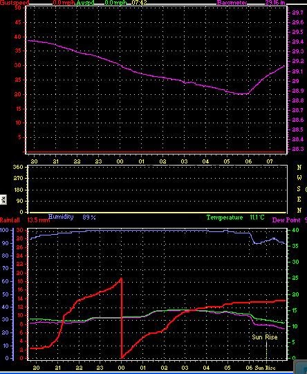
The following picture is a screen copy from my weather system which shows the change in pressure as the storm passed through (top graph):


The lower graph shows the rainfall (red line) which reset at midnight, showing the large amount of rain yesterday evening and this morning. The green line in the lower graph shows temperature. Interesting to note the fall in temperature coincides with the increase in air pressure in the top graph.

Monday, 21 October 2013

No Wonder I Was Getting A Poor SWR !!

A week ago I tried to tune my FT2000 on 40m via the external SGC Smart Tuner but it would not tune up and the meter on the FT2000 was showing an infinite SWR, not good!.

This weekend I was able to get outside on Sunday despite really bad weather and this is what I found:


No wonder it would not tune up.

The cable usually breaks where it passes through the insulator at the 90 degree bend in the inverted L. As shown in an earlier post, it is this insulator which has been up for so long that the majority of the insulator has been engulfed in the branch. It was originally loose, held by some rope around the branch, this was 14 years ago when I first received the M5LMY licence which meant I could get on the HF bands.

Over those 14 years, the branch has gradually grown around the rope, then the insulator so that now more than 50% is buried within the branch. In another 5 to 8 years I guess it will disappear altogether.

The cable breaks at this point as there is no flexibility with the insulator so the cable is rubbing on the fixed insulator and wears through.

The weather yesterday has really bad. Raining for much of the day with some intense bursts along with thunder and lightning. The following is from my weather station, the red line showing rainfall:


In total today we had 22.4mm of rain.

Monday, 16 September 2013

A Weekend of Bad Weather

The weekend weather here in the south of the UK has been terrible. Grey sky, rain and winds. The following satellite picture from Sunday gives a good view of the weather we were under:


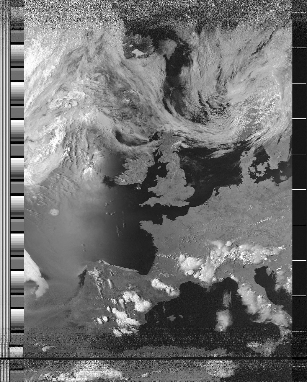
This is the NOAA 19 pass from Sunday at 12:55. Ireland was generally cloud free and the north of the UK had some breaks in the cloud, however a large sweep of cloud over the south of the country.

Another good satellite pass from the north of Africa to Iceland. Not bad for a loft mounted pair of crossed diploes.

Thursday, 11 July 2013

Weather Satellite Pictures Keeping Getting Better

Another day of good weather and another day of very good APT weather satellite pictures.

The following is from the 13:05 UTC pass of NOAA 19, again with most of the UK cloud free.


It is a cropped image, however the overall duration of  the pass was again excellent and shows what can be done with a simple loft antenna.

The cloud cover coming off the North Sea onto to east coast is quite a common occurrence. It is interesting to compare what the weather is like at ground level against the satellite picture. There are many really good webcams that enable this to be done very easily. A good set of webcams on the coast of Norfolk are on the Happisburgh Lighthouse. See the following link: http://www.happisburgh.org/webcam

The whole Happisburgh site is worth a read and the village is well worth a visit. Check for the days when the Lighthouse and the Church Tower are open. Views from the top are excellent.


Tuesday, 9 July 2013

Good Weather At Last !

The weather for the last week has been excellent with high pressure covering much of the country resulting in very warm conditions, reaching 28C and clear skies.

As well as Eumetcast, I still receive APT transmissions from the NOAA satellites and during summer with the sun at a high angle the received pictures are excellent.

The following is the picture as received (with minor contrast enhancement) from NOAA 15 late this afternoon:


Most of the United Kingdom is cloud free and London and Birmingham stand out well as slightly darker than their surroundings.

I receive the polar orbiting NOAA satellites using a Timestep receiver which is almost 20 years old and has been in use almost 24 by 7 for all that time. The antenna is a turnstile cross dipole style of antenna located in the loft of the house which makes the duration of pass and received quality all the more surprising.

The Timestep receiver feeds audio to the computer soundcard and the audio is processed into pictures by the excellent WXtoImg.


Sunday, 26 May 2013

Good Weather At Last !

Following my comments on Friday about the very poor weather we have been having, we have finally had a good weekend. Contrast the following satellite picture received Sunday with the one received on Friday.  Clear skies at last.


© EUMETSAT (2013)

Friday, 24 May 2013

Dreadful Weather and Receiving Weather Satellite Pictures

For almost the end of May, the weather has been dreadful today with temperatures staying around 6 degrees centigrade all day, lots of rain (10mm) and strong winds. The cause has been an area of low pressure tracking from the northeast to the southwest directly across the country.

For monitoring weather I receive weather satellite pictures transmitted by EUMETSAT via the EUMETCast system. With both static pictures and the ability to build an animation over time, the EUMETCast facility provides a fantastic way of watching what is going on, and seeing the cause of the weather we get on a day to day basis.

The following picture is from the early afternoon and shows the core of the low pressure area approaching the Wash, it continued tracking south west for the rest of the afternoon. very unusual pattern for this time of year.


© EUMETSAT (2013)
EUMETCast also distributes a 5 minute updated picture, these can be built up into an animation to show how the weather changes over a period of several hours. Perfect for watching the track of weather systems.

I will provide more details of my receiving system in a future post. For now, an excellent source of information is from the Group for Earth Observation http://www.geo-web.org.uk/ and full details of EUMETSAT services are at http://www.eumetsat.int/Home/index.htm

For decoding and displaying all the data received via EUMETCast I use the excellent software available from David Taylor at http://www.satsignal.eu/

On the Radio, worked one of the many special event stations operating at the moment. GS5NB was operating on 40m from the Ness Battery on the Orkney Islands. See http://www.qrz.com/db/GS5NB for details.